Maps as conversations
Exploring our citizen led neighbourhood mapping at Data For Action
Introduction: Reimagining ‘Place’ and Data
We often talk about data collection and service delivery in neatly defined neighbourhoods, wards or districts. But people don’t tend to live their lives according to these administrative lines. People don’t talk about or recognise wards, they recognise physical markers, personal relationships and neighbourhoods.
That’s why we at Data for Action have spent the past few years working with local organisations and communities in Sheffield to better understand how people define ‘their place’. By creating a bottom-up, citizen-led map of neighbourhoods, we’ve begun to see a shift: when people recognise themselves in the data, they feel more inclined to engage, talk about local issues, collaborate on solutions and build resilience together. You can view the story so far here
What We Did
Gathering Multiple Perspectives
- Listening First - we spent time hearing how residents and local groups naturally describe their patch of the city. This gave us a more human picture than simply using council ward boundaries.
- Comparing Existing Maps - We looked at local authority data and informal, community-driven definitions. Unsurprisingly, there’s plenty of overlap but also many hidden nuances about how people view their area.
Developing an Open, Evolving Map
- Collaborative Tools - We used digital platforms (e.g. Felt, maptionnaire) to help people draw and label their own places of identity. We also held face-to-face workshops for those who prefer pens and paper over online tools.
- Continuous Input - We didn’t want this to be a one-off exercise. Instead, we’ve kept it open so that more voices can continually refine and expand the map.

An open map of neighbourhoods with continuous feedback. You can see the live map here.
Extending the Approach to Specific Communities
- Health and Community Services - We collaborated with organisations such as ISRAAC to overlay local health services (e.g. GP surgeries, voluntary support groups) onto the community maps, aiming to highlight gaps and opportunities for better health outcomes.
- Community Researchers - Local volunteers helped gather on the ground insights about people’s experiences and preferences for accessing services. This approach not only captured richer data but also built local research capacity and is a vital part of our approach. We work with people, communities and organisations that are already there.
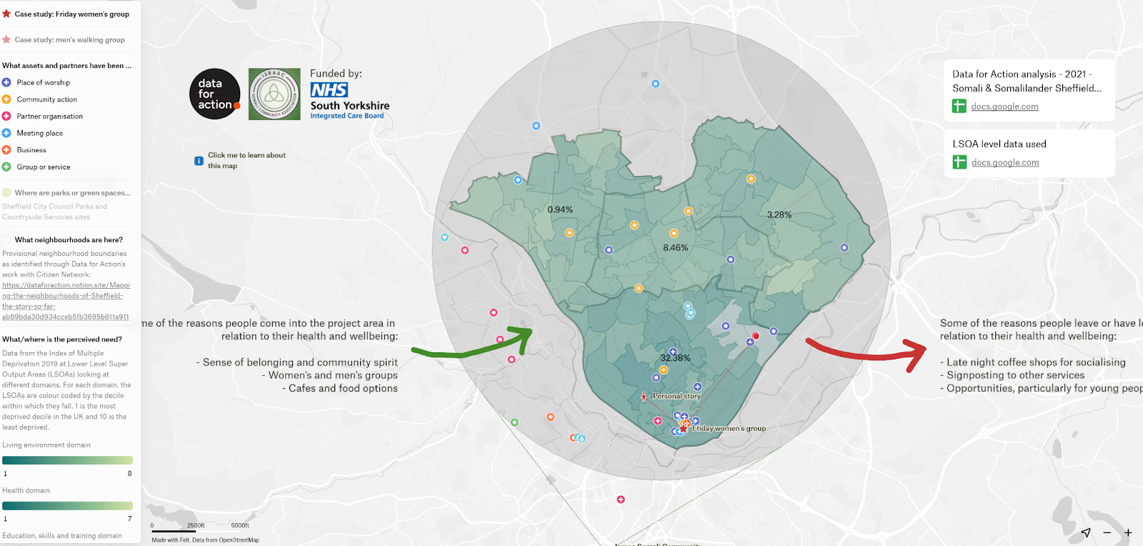
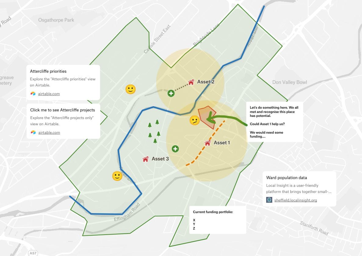
A map built upon the original neighbourhoods focusing on specific communities and support services. The map shows both where communities are, what they access and importantly the movement and links between these. We feel this aspect of movement and connection is vital and often overlooked (it’s the lines not the dots). You can see the live map here.
Showing the work
- Open Documentation - Throughout, we shared our methods, data and reflections openly, so anyone can learn from what we’re doing.
- Growing Partnerships - A range of stakeholders including local authorities, health bodies, and voluntary organisations are starting to see how mapping neighbourhoods “as people see them” can inform planning, funding and community action in a more meaningful way.
Why Does This Matter?
Meaningful Engagement
When people recognise their own neighbourhoods and networks in official data, they’re more likely to:
- Converse at a human level about challenges and opportunities.
- Engage with local initiatives and offer ideas.
- Take ownership of community challenges.
- Create partnerships that cross perceived boundaries.
Improved Service Design
Service providers, from the NHS to local authorities, gain:
- Insights that might otherwise remain unseen, especially regarding health inequalities.
- Stronger foundations for decision making with (rather than for) communities.
- A more focused approach for directing resources where they’re truly needed.
Model for Wider Application
Although this project began in Sheffield, we believe the key principles of community-driven mapping, partnership work, and transparent data-sharing can be adapted anywhere. The approach can:
- Break Down Barriers between formal institutions and the people they serve.
- Stimulate Local Democracy by decentralising power and information.
- Build Long-Term Resilience as communities learn to collect and use data to drive their own priorities.
Why Other Places Should Pay Attention
Replicable Blueprint
The community mapping process can be replicated to:
- Identify unique community assets
- Tailor services and investment
- Build Trust between citizens and Local Agencies
Immediate and Future Benefits
- Shining a spotlight on local resources can make it easier for people to find help, share assets and support each other
- When communities co-own the data and update it over time, it builds a more resilient civic infrastructure, one that adapts as needs evolve. Different groups, some formal, others informal are now taking ownership of different neighbourbood maps, add insight and having conversations about what the maps are showing, and what this means.
A Platform for Innovation and Citizenship
Once communities have established their own boundaries and mapped assets, they can explore further applications, from digital democracy platforms to participatory budgeting, all anchored in a genuine sense of local identity.
A Shared Vision for Place-Based Change
What started as an idea “Everything happens in a place” has turned into a practical, replicable initiative. Through the power of citizen-led mapping, Sheffield’s communities have already begun to shift how we talk about places, how we deliver services, and how we make decisions together.
We think other areas now have the chance to adapt and benefit from this model. By grounding policy and practice in how people actually live, connect and identify, localities can cultivate greater participation, more cohesive relationships and a richer sense of community ownership.
How Data For Action can help
We provide the blueprint, the digital tools and the methodology and work with local organisations to help them build and create the maps. We believe in local ownership of the knowledge and insights and want to build the skills of local organisations to carry this work on in the future.
We'd love to support this work in more places. If you want to explore doing this work in your place, get in touch with us hello@dataforaction.org.uk